A. Exploratory research
I. Project n°1 : Marine Wildlife

1. Project carriers
Chantal D. Pagel, PhD
2. Beneficiaries
The marine life benefit from this project.
3. Users
The marine wildlife enthusiast who likes to be informed about everything marine wildlife tourism-ish
and also some tourists who simply need input and advice for their next marine wildlife watching experience.
4. Need
The need of this project is promote responsible interactions with marine wildlife,
in order to enhance the overall safety of both people and marine wildlife when they are interacting in the animals’ natural environments.
5. Principe
The project create an online information platform on wildlife tourism in the marine environment to share knowledge and to spread the word.
They want to help by providing information on guidelines/codes of conduct as well as general “do’s & don’ts” when getting close to marine life.
6. Main technologies involved
The social Media Platform & Online Platform.
7. Sources
http://marine-wildlife.org/home.html
II. Project n°2 : SeaPhoto Apps

1. Project carriers
Monterey Bay National Marine Sanctuary, US GOV
2. Beneficiaries
The tourist and the marine enthusiast benefit from this application.
3. Users
Teachers, students, beachgoers, researchers and tourists.
4. Need
There are a variety of resource protection issues within this Sanctuary region due to the sensitivity of habitats and species in the region, the long stretch of adjacent populated coastline, and the multiple uses of the marine environment.
The need the project is let people and tourists better understand a wealth of information about central California marine life through this application.
5. Principe
The app includes more than 1300 photos of marine life, some with detailed ecological information.
In addition to the photos of marine life, the mobile app includes an extensive, searchable glossary of common and scientific names. Users can save their favorite photos and share them via Twitter and email.
The app also provides general information about the Office of National Marine Sanctuaries and links to the sanctuary's web site and its YouTube channel.
6. Main technologies involved
A mobile App.
7. Sources
https://apps.apple.com/us/app/seaphoto/id515571588
https://sanctuaries.noaa.gov/visit/mobile-apps.html
III. Project n°3 : Blue Discovery

1. Project carriers
Blue Thread Navigation Technology.
2. Beneficiaries
The tourists, the tourism and the marine life.
3. Users
Marine Protected Areas and Tourist Ports are main stakeholders and users of the system, but the true end-user is the visitor.
4. Need
5. Principe
They want to create the BlueDiscovery System, an innovative and powerful technology platform that allows for the deployment of an efficient and low-cost Access Control and Visitor Information System to Marine Protected Areas (MPAs). The same concepts and main functions apply also to Tourist Ports.
It introduces a new and more efficient control model, by means of a real-time management and automatic support to all visitors during their visit, guiding them to ‘discover’ the hidden jewels of the marine area in an easy and immediate way and allowing for an overall optimization of the MPA resources. Purpose of the system is environmental conservation achieved through a cooperative and conscious use of the Nature Reserve by the visitor.
6. Main technologies involved
A Client-Server & DB-based architecture, consisting of a client mobile App free downloadable on any mobile device (smartphones and tablets), a web-GIS.
7. Sources
https://business.esa.int/projects/blue-discovery-1
Picture Source
IV. Project n°4 :Debris Tracker Apps
1. Project carriers
Debris Tracker is powered by Morgan Stanley in partnership with National Geographic Society and the University of Georgia. The app was developed in 2010 by the NOAA Marine Debris Program and the College of Engineering at the University of Georgia.
2. Beneficiaries
The marine life benefit from this project.
3. Users
The tourists, beachgoers and researchers.
4. Need
This app allows users to report trash found along coastlines and in waterways. It’s easy to use, and allows you to accurately enter items of trash spotted while out in the water.
5. Principe
The app allows user to both classify the trash from a list and enter a quantity and description.
The app then pin the trashs on a map exactly where the user found them. The resulting pushpin map displays debris logged by all users and helps researchers uncover trends in marine debris.
6. Main technologies involved
The mobile App, The GPS, Databases.
7. Sources
https://debristracker.org/
https://www.sailmagazine.com/gear/three-apps-for-ocean-protection
Picture Source
B. Deeping
I. Project n°4 : Debris Tracker Apps


Picture Source
Picture Source
Picture Source
1. Carriers and actors of the project
The NOAA Marine Debris Program and the College of Engineering at the University of Georgia carry the project.
Actors: The dedicated educational, non-profit, and scientific organizations and passionate citizen scientists and tourists from all around the world record data on inland and marine debris with this easy-to-use app, contributing to data collecting, scientific research and marine life protection.
2. Research question
How can we motivate tourism industry to collect marine debris data with their phones in order to contribute to academic research?
3. The reason of selection this project
Because through this project, tourists and the tourism industry will be more aware of marine debris.
This app can be used to track and collect trash in order to reduce marine debris, it allows users to intuitively experience the impact of rubbish on marine life.
At the same time, lessen the harm to marine life and strengthen its protection.
Furthermore, the collected open data allows scientists to contribute more to academic research.
Moreover, tourists can utilize the information gathered to plan their trips and choose destinations.
II. User scenario
1. Users
The tourists, beachgoers and researchers.
2. Persona
Persona

3. Key features
4. UX storyboard
UX storyboard


III. Technical analysis
1. General principle
The app allows user to both classify it from a 46-item list and enter a quantity and description. The app then uses user‘s GPS coordinates to pin the recovered items on a map exactly where the user found them.
They have a hugh open database which can view all data from around the world. Filter by date and category, and choose what categories to include in graphs.
2. Technical overview - AI version
This is an artificial intelligence that can collects observations of water levels, currents, and winds, atmospheric pressure, air temperatures.
After a lot of computations using artificial intelligence, he can figure out where these trash will be buried on the earth, for different types of garbage, how long it will take for the rubbish to degrade. Or, even worse, Before the rubbish was washed ashore by the sea, it was already eaten by fish.
This AI is based on supervised learning, and it will manipulated some values, images and words.
The algorithm have to perform Classification, generation, pattern identification, clustering, regression.
it will using some datasets from water level stations who equipped with meteorological and additional oceanographic sensors to collect observations such as wind speed and direction, temperature, water levels, currents, and atmospheric pressure. and this data will be labelled, then this AI provides users with forecast on the final position of trash , the forecast systems will implemented the combination of real-time data, predictions, data management.
It will use python to programmed, it will use Naive Bayes, Decision Tree, Ensemble Algorithms, Regression algorithms.
it will also used Sklearn library, Numpy library, DecisionTreeLearner etc. to do the algotithms.
3. Added value thanks to Artificial Intelligence
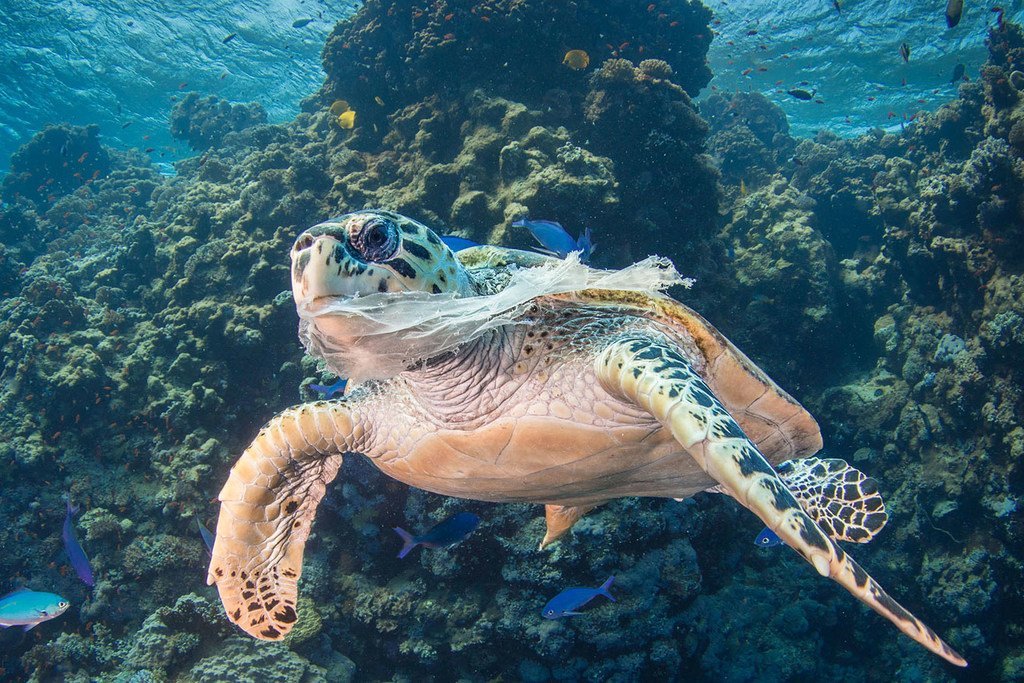
When people use the application, the AI will let people intuitively feel the pollution of the marine environment by the rubbish. People will be able to see some photos of the trashs eaten by marine life, the photos of the trash on the bottom of the sea.
And if they will noticed that if they choose not to pick up this rubbish, the AI will show the final destination of these garbage which will pollute some tourist attractions, the marine, even the citys they lived.